Tag: geology

Jurassic Park : Blackcomb is 50-70 million years older than Whistler Jurassic Park : Blackcomb is 50-70 million years older than Whistler 

0 Comments

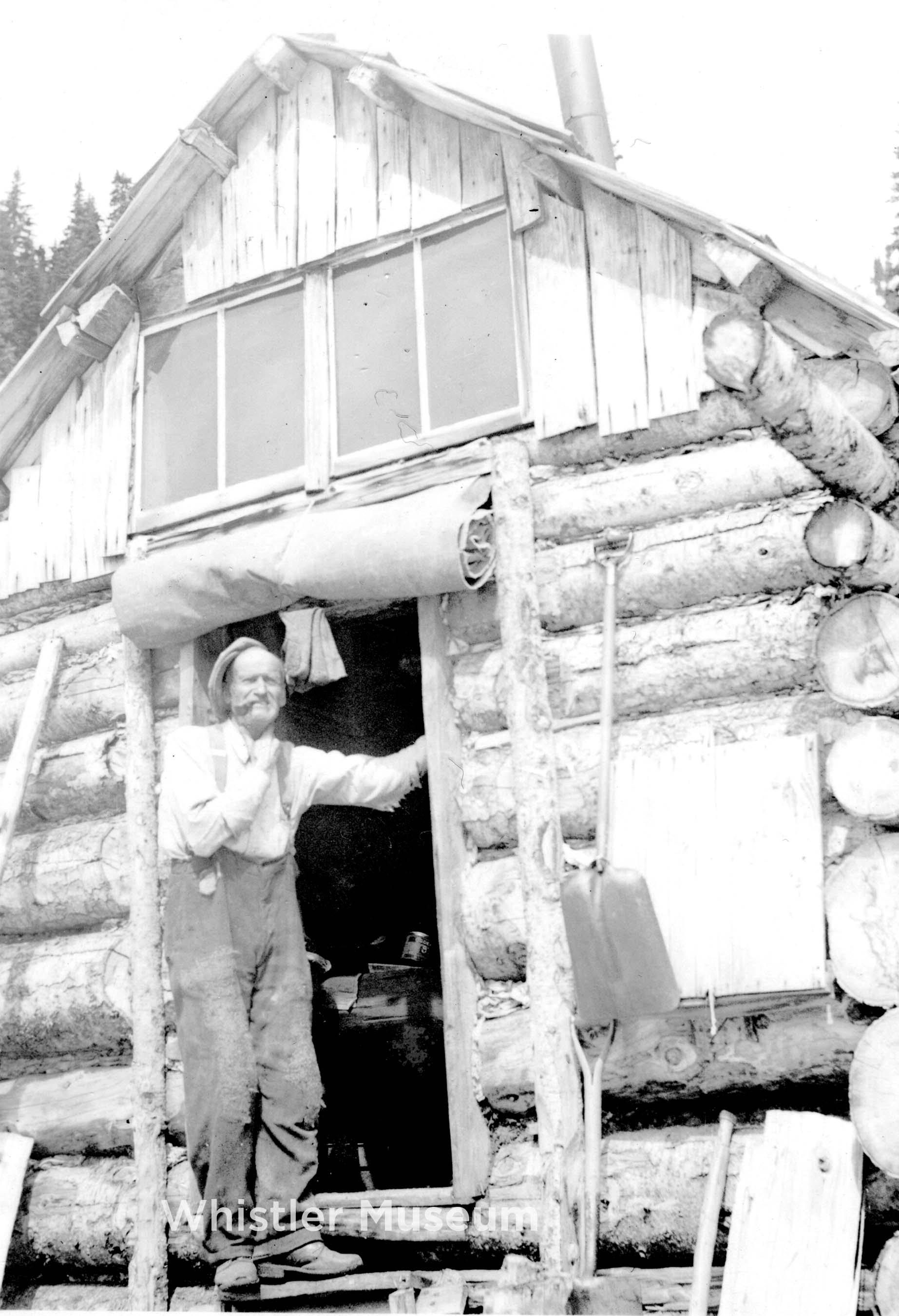
Featured Image: Prospector Henry ‘Harry’ Horstman arrived in 1913. Though Horstman Glacier and Hut on Blackcomb are named after him, he did not stake any claims on the mountain. Photo: Brock Collection.

‘The Fault of Fitzsimmons’

Whistler and Blackcomb mountains have very different histories.

Their differing stories far predate the 80s and 90s ‘Duel of the Dual Mountains’ which played itself out in past battles to access vaster and more expansive alpine ski terrain, faster (a one-upping between once-independent resorts, jostling for prominence, where the launched weaponry was the 7th Heaven T-Bar with the retaliatory firing of the Peak Chair, followed by 7th Heaven Express and Peak Express)…

We’re not talking decades-ago-differences, here.

Peak Chair. Griffith collection.

We are speaking about epochs, eras, periods… years. Hundreds of millions of them.

We are talking geology and geography: the language of our local landforms.

We are speaking about the background of our backyard rocks: what follows is a barebones breakdown of the basics.

Blackcomb came first. A product of the Jurassic Period, the mountain is about 150 million years old. Blackcomb is formed primarily of hard, salt-and-pepper coloured granodiorite. Granodiorite forms about 80% of the Coast Mountains: igneous rock, developed from cooled and crystallized magma protons. It would be fair to say when venturing on Blackcomb, one is entering Jurassic Park. 

Whistler is about 80 million years old. It is formed of sedimentary, volcanic rock: shale and andesite, deposited in a marine basin during the Cretaceous Period. Fossils can be found high atop its peak. It was once the ocean floor. During the summer, the famed ‘Shale Slope’ appears as a red streak, visible as one rides the Peak Chair: rising through the stratas of geologic upheaval.

“The reason there is such diverse geology crammed together in the Whistler area is that the rocks are exotic and were actually formed in different geological settings, hundreds or thousands of kilometers west and south of where they are now. Over time, they were transported by massive oceanic plates like a conveyor belt to the West Coast, until 100 million years ago when they started to “accrete” (stick on) to continental America,” wrote geologist Steve Carney for the Whistler Naturalists (2023). 

Blackcomb was (as were Wedge, Weart and Cook) pushed up by the Pacific Plate. Whistler rose up due to tectonic action of the Fitzsimmons Fault: the dividing valley line between Blackcomb and Whistler and “a recurring geologic feature in the valley and around the townsite,” according to Fire and Ice, the website spearheading the petition to have the area designated a UNESCO GeoRegion. The Fitzsimmons Fault line runs directly through Whistler’s Ego Bowl and is also clearly exposed along a 4-km stretch of Hwy 99 between Creekside and Whistler Village. It can be identified by its “mineral-rich rocks whose yellow cast is the result of sulfuric gasses circulating over thousands of years deep in the fault zone.”

The Fault, Valley and Creek that runs through it (into Green Lake) is named after prospector Jimmy Fitzsimmons. The miner staked copper claims, and dug for metals – in shafts still visible – along the Singing Pass Trail. 

Just opposite, on Blackcomb’s lower flanks, prominent “gossans” can be seen. Fire and Ice describe them as “outcrops of oxidized and heavily metamorphosed rocks that can indicate the presence of ore deposits.”  

Prospecting forms an active part of the area’s ‘more recent’ history. Whistler was known previously as London Mountain: likely named for the mineral claim “staked for Frederick James Proctor of the London & British North America Mining Co. of Vancouver, in 1903,” according to the BC government. The Horstman Glacier (and hut) on Blackcomb were named after the prospector who arrived in the area in 1913 in search of gold. However, ironically, Horstman did not stake any mining claims on Blackcomb.

Down in the valley,  in the rich wetlands of the Fitzsimmons Delta, the Alta Lake Mining Company began mining in 1916 for iron. The metal originated from the mineral-rich from the towering igneous rocks, and was transported in groundwater and runoff into the lakeside bogs where it oxidized and was deposited as “bog iron.” At its height, the company was producing 150 tonnes of iron per day, which it transported by railway to Squamish, then onward to Washington state. 

From plates to peaks, the local area is one of the most geologically diverse.

For more information about local geological features visit https://fireandicegeoregion.ca and https://www.whistlernaturalists.ca. 

Shaping the landscape with fire and iceShaping the landscape with fire and ice

0 Comments

In the weekly Museum Musings column in Pique Newsmagazine, we mostly explore and share stories of the past. Rarely, however, do we go back thousands or millions of years as is required when talking about the geological history of our region. In celebration of the Sea to Sky Fire and Ice Aspiring GeoRegion, the Museum is showcasing the landscape in the new exhibition Shaping the Landscape with Fire & Ice.

Throughout time, fire and ice have played an important part in shaping the land. Whistler sits in the subduction zone of converging tectonic plates, where the Juan De Fuca plate is being pushed under the North American plate, creating the Coast Mountains. All of the volcanoes considered active in Canada are found in BC and the Yukon along tectonic plate boundaries, and all are part of the Pacific Ring of Fire.

Garibaldi Provincial Park is named after Mount Garibaldi, the largest mountain in the park and a potentially active stratovolcano. While the last eruption was around 13,000 years ago, this is still relatively recent in geological time (Black Tusk, on the other hand, likely erupted approximately 170,000 years ago). Volcanoes can erupt again after being dormant for thousands of years. Thankfully, if Mount Garibaldi was to rumble back life to we would start seeing warnings such as hot springs, hot spots and seismic activity in the region from rising magma.

Fire and ice shaped this region, creating the unique mountains that are popular for recreation. Greg Griffith Collection.

While Mount Baker is instantly recognisable as a volcano, Mount Garibaldi is harder to distinguish because it is not a typical cone shaped volcano. When Mount Garibaldi erupted during the last ice age, one half of the volcanic cone formed on a rock foundation, while the west side settled on top of a glacier. As the glacier melted and receded the mountain collapsed, changing shape. Giant landslides spread the volcanic debris across the Squamish Valley.

We can thank this active volcanic region for the formation of Garibaldi Lake. Also around the end of the last glaciation, Clinker Peak on the shoulder of Mount Price erupted. The Cheakamus Valley had been full of ice over 1.3 km above sea level that was rapidly melting. Lava from the Clinker Peak eruption flowed towards the valley below where it hit the Cheakamus Valley glacier. There it cooled rapidly against the wall of ice, solidifying to create a dam across the mountain valley. As snow and ice melted from the mountains above it became trapped behind this wall, known as The Barrier, creating Garibaldi Lake.

Garibaldi Lake. Cliff Fenner Collection.

The only water that leaves Garibaldi Lake year round gushes from springs coming through the scree slope below The Barrier. This consistent flow of water lubricates the bottom of the naturally unstable dam and poses a significant geological hazard, with some scientists worried it could one day collapse. It is not uncommon to see rocks fall from The Barrier, hence the name of Rubble Creek below, and according to indigenous oral histories a major landslide occurred 1855 when a slab of rock fell from The Barrier. With approximately 1.28 trillion litres of water trapped by an unstable dam wall at 1400 metres of elevation, a collapse could be catastrophic. It is for this reason that an evacuation order of Garibaldi Townsite was issued in 1980, with the last residents leaving the town in 1986. Today the Garibaldi Townsite no longer exists. 

Hikers looking at The Barrier around the 1960s or 1970s. Cliff Fenner Collection.

Shaping the Landscape with Fire & Ice is on now at the Whistler Museum, open from 11am every day except Wednesday. Entry is by donation, and you can further support the Whistler Museum by becoming a Museum Member.

Whistler’s Lakes: Records of Environmental Change in Alta and Lost LakesWhistler’s Lakes: Records of Environmental Change in Alta and Lost Lakes

2 Comments

*Due to generous private support, this event will now be offered with FREE ADMISSION

Dr. Ian Spooner (Acadia University, Nova Scotia) is an environmental scientist who uses lake sediment records to determine how development, atmospheric pollution and local geology influence lake water quality and chemistry.  Over the past seven years he and his students along with staff at Cascade Environmental Resource Group have studied the sediment records in Alta Lake and, more recently, Lost Lake.

Both lakes have provided detailed and complex records of environmental change dating back to the 1700s.  Research to date has indicated that both natural processes and anthropogenic influences have had a significant impact; the data provides some guidance for future development in both watersheds.

Thursday, April 11 Ian will be at the museum to show how the lake records were obtained and analyzed and discuss what they can tell us about both the resilience and vulnerability of these lakes to future environmental change.  Local context (written records, personal experiences) is critical to effective interpretation of the lake sediment records and he hopes that everyone who has an interest in or a story about our lakes can attend.

Dr. Ian Spooner (Department Head, P. Geo) has been a professor at Acadia in the Earth and Environmental Science Department for 25 years.  His primary research interest is using lake sediment records to investigate environmental impact and he has active research programs in Atlantic Canada, Alberta and British Columbia.  His secondary research interests include applied geomorphology (fluvial, coastal) and landslide hazard assessment.  He also has consulted in the areas of environmental risk assessment, groundwater and surface water contamination, coastal erosion and has been involved in hazard assessments for resource companies in Nova Scotia, British Columbia and the Northwest Territories.

Taking Stock of Glacial Loss in Garibaldi ParkTaking Stock of Glacial Loss in Garibaldi Park

0 Comments

A few weeks ago, we had the pleasure to run into a pair of glaciologists performing research in Garibaldi Provincial Park. They let us tag along and see what a day of glaciological fieldwork entailed.

Their focus was the Helm Glacier, a slender icefield four kilometres southeast of Black Tusk most commonly accessed from the Cheakamus Lake trailhead.

Jason Vanderschoot and Mark Ednie arrive at the day's jobsite. Jeff Slack photo.
Jason Vanderschoot and Mark Ednie arrive at the day’s jobsite. Jeff Slack photo.

Helm Glacier is important because it has a solid baseline of data; it has been continuously monitored since the late 1960s. Moreover, multiple photographs taken by mountaineers as far back as the 1920s help give an even better indication of the glacier’s change over time.

This change has been consistent: rapid retreat. Between 1928-2009, Helm Glacier lost an estimated 78% of its mass, and it has shown no signs of slowing down. In fact, in a database of sixteen North American glaciers with extensive and comparable datasets, Helm has experienced the most rapid melting of them all.

Satellite imagery from 2009 outlining the Helm Glacier's historical extent. Imagery credit Mauri Pelto,
Satellite imagery from 2009 outlining the Helm Glacier’s historical extent. Imagery credit: Mauri Pelto,

The two glaciologists, working for the Geological Survey of Canada, were measuring vertical surface loss, that is, the extent to which the glacier’s surface has dropped since the previous summer. This is done by drilling six-metre long metal poles vertically into the glacier, then returning the following year to measure how much of the pole has become exposed. The drills are human-powered; all the drilling and the hike to the glacier and back makes for a long day of hard, physical work.

Fascinating caverns and tunnels are emerging along the edges of the fast-retreating glacier. Jeff Slack photo.

Last year’s results indicated that the glacier’s surface had lowered an average of 4 vertical metres on the lower glacier, and roughly 3.5 metres higher up. Numbers still need to be crunched, but preliminary data for this year suggests smaller losses, roughly 2.6 metres at the bottom and 2.2 metres at the top.

This is not surprising, as two winters ago our region experienced historically low snowpack levels, followed by a long, hot summer (remember those massive forest fires?). Last winter, Whistler Mountain measured a slightly above average snowpack, and this summer has been closer to average as well. Still, on September 29th (the day we were up there) there was hardly any seasonal snow left on the surface of the glacier. This year was not as hard on the glaciers as last, but we still lost a lot of ice.

Hand-drilling five metres down into the glacier is low-tech hard work, but these gus weren't complaining. Jeff Slack photo.
Hand-drilling five metres down into the glacier is low-tech hard work, but these gus weren’t complaining. Jeff Slack photo.

After the Helm Glacier research was completed, the pair headed up to their research station on the Place Glacier, north of Pemberton, to conduct further studies. When compared to similar data from hundreds of other glaciers around the world, this research is creating a fuller understanding of past, present, and future environmental change. Much thanks to these intrepid scientists for the work they do, and for letting us tag along for the afternoon!

rocks1.jpg
Where’s Waldo, glacier-style.
Helm Glacier Panorama. Jeff Slack photo.