Tag: geography

Jurassic Park : Blackcomb is 50-70 million years older than Whistler Jurassic Park : Blackcomb is 50-70 million years older than Whistler 

0 Comments

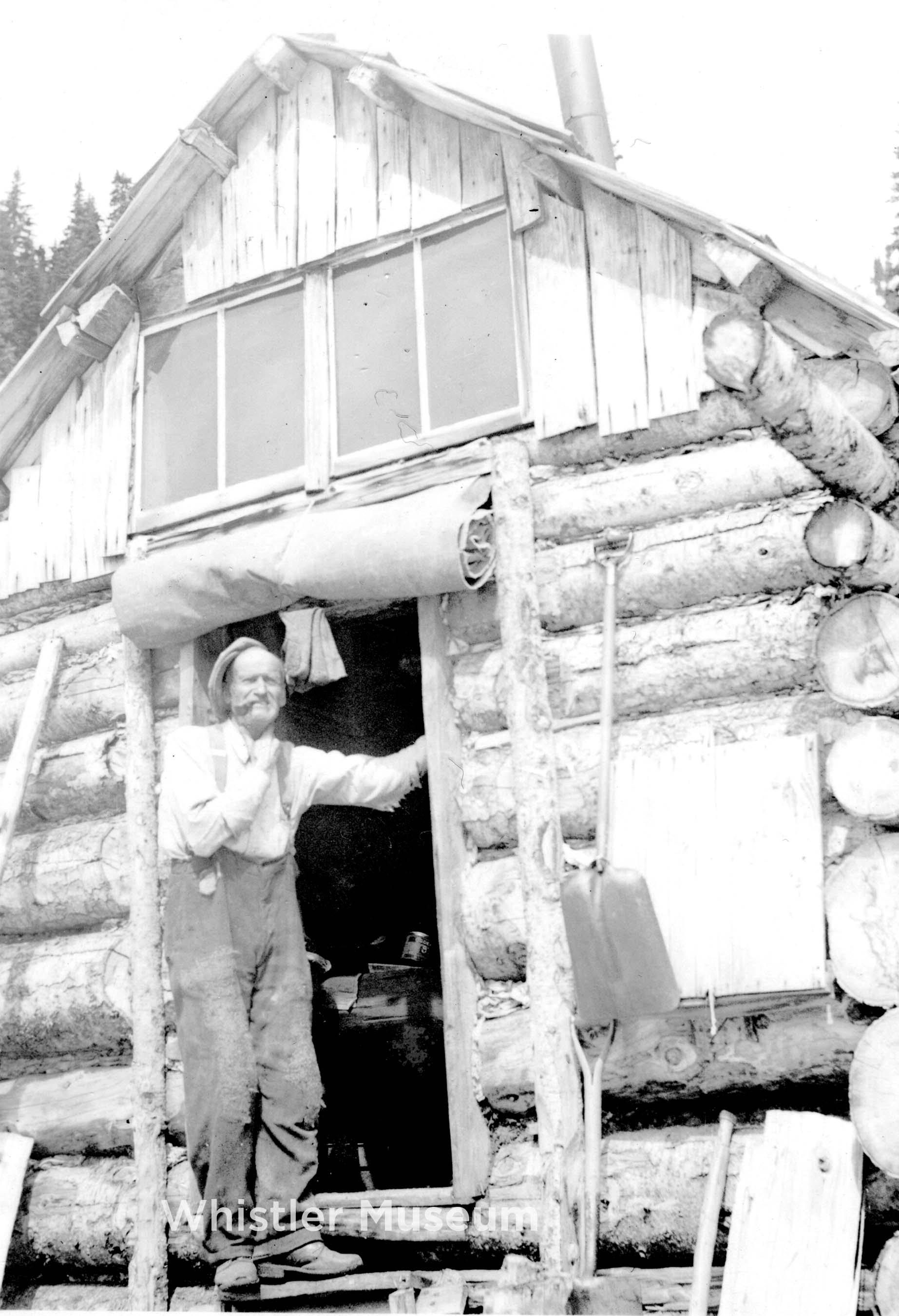
Featured Image: Prospector Henry ‘Harry’ Horstman arrived in 1913. Though Horstman Glacier and Hut on Blackcomb are named after him, he did not stake any claims on the mountain. Photo: Brock Collection.

‘The Fault of Fitzsimmons’

Whistler and Blackcomb mountains have very different histories.

Their differing stories far predate the 80s and 90s ‘Duel of the Dual Mountains’ which played itself out in past battles to access vaster and more expansive alpine ski terrain, faster (a one-upping between once-independent resorts, jostling for prominence, where the launched weaponry was the 7th Heaven T-Bar with the retaliatory firing of the Peak Chair, followed by 7th Heaven Express and Peak Express)…

We’re not talking decades-ago-differences, here.

Peak Chair. Griffith collection.

We are speaking about epochs, eras, periods… years. Hundreds of millions of them.

We are talking geology and geography: the language of our local landforms.

We are speaking about the background of our backyard rocks: what follows is a barebones breakdown of the basics.

Blackcomb came first. A product of the Jurassic Period, the mountain is about 150 million years old. Blackcomb is formed primarily of hard, salt-and-pepper coloured granodiorite. Granodiorite forms about 80% of the Coast Mountains: igneous rock, developed from cooled and crystallized magma protons. It would be fair to say when venturing on Blackcomb, one is entering Jurassic Park. 

Whistler is about 80 million years old. It is formed of sedimentary, volcanic rock: shale and andesite, deposited in a marine basin during the Cretaceous Period. Fossils can be found high atop its peak. It was once the ocean floor. During the summer, the famed ‘Shale Slope’ appears as a red streak, visible as one rides the Peak Chair: rising through the stratas of geologic upheaval.

“The reason there is such diverse geology crammed together in the Whistler area is that the rocks are exotic and were actually formed in different geological settings, hundreds or thousands of kilometers west and south of where they are now. Over time, they were transported by massive oceanic plates like a conveyor belt to the West Coast, until 100 million years ago when they started to “accrete” (stick on) to continental America,” wrote geologist Steve Carney for the Whistler Naturalists (2023). 

Blackcomb was (as were Wedge, Weart and Cook) pushed up by the Pacific Plate. Whistler rose up due to tectonic action of the Fitzsimmons Fault: the dividing valley line between Blackcomb and Whistler and “a recurring geologic feature in the valley and around the townsite,” according to Fire and Ice, the website spearheading the petition to have the area designated a UNESCO GeoRegion. The Fitzsimmons Fault line runs directly through Whistler’s Ego Bowl and is also clearly exposed along a 4-km stretch of Hwy 99 between Creekside and Whistler Village. It can be identified by its “mineral-rich rocks whose yellow cast is the result of sulfuric gasses circulating over thousands of years deep in the fault zone.”

The Fault, Valley and Creek that runs through it (into Green Lake) is named after prospector Jimmy Fitzsimmons. The miner staked copper claims, and dug for metals – in shafts still visible – along the Singing Pass Trail. 

Just opposite, on Blackcomb’s lower flanks, prominent “gossans” can be seen. Fire and Ice describe them as “outcrops of oxidized and heavily metamorphosed rocks that can indicate the presence of ore deposits.”  

Prospecting forms an active part of the area’s ‘more recent’ history. Whistler was known previously as London Mountain: likely named for the mineral claim “staked for Frederick James Proctor of the London & British North America Mining Co. of Vancouver, in 1903,” according to the BC government. The Horstman Glacier (and hut) on Blackcomb were named after the prospector who arrived in the area in 1913 in search of gold. However, ironically, Horstman did not stake any mining claims on Blackcomb.

Down in the valley,  in the rich wetlands of the Fitzsimmons Delta, the Alta Lake Mining Company began mining in 1916 for iron. The metal originated from the mineral-rich from the towering igneous rocks, and was transported in groundwater and runoff into the lakeside bogs where it oxidized and was deposited as “bog iron.” At its height, the company was producing 150 tonnes of iron per day, which it transported by railway to Squamish, then onward to Washington state. 

From plates to peaks, the local area is one of the most geologically diverse.

For more information about local geological features visit https://fireandicegeoregion.ca and https://www.whistlernaturalists.ca. 

Mountain Profile: The TableMountain Profile: The Table

0 Comments

Of all the glorious mountains the surround Whistler, The Table has got to be  unique.

pacific.jpg
Approaching the Table in a helicopter with Pacific Ski Air, circa 1970. Cliff Jennings Photo

This curious flat-topped mountain near Garibaldi Lake was formed when a volcanic eruption burst up through a massive glacier, roughly 10-15,000 years ago. The fast-melting ice kept the lava flow contained on the sides and forced it to cool off and solidify quickly, while the pull of gravity caused the nearly perfect flat top.

Scientists have been able to date it to quite recently since there are no signs of glacial erosion along the sides or base. This indicates that the initial eruption and formation occurred after the great Holocene ice sheets were in retreat, but obviously before they were completely gone, roughly 10-12,000 years ago.

In geological terms, a flat-topped volcano formed through this spectacular interaction between fire and ice is called a tuya. These are extremely rare, being found in Antarctica, Iceland, Siberia, Coastal BC, the Oregon Cascades, and not much else.

bury.jpg
As seen from Panorama Ridge during the 1939 George Bury ski expedition.

The Table sits within the midst of a highly active and scenic volcanic setting, with the Black Tusk, Cinder Cone, Mount Price, Mount Garibaldi, The Barrier, and several other nearby volcanic features. As a whole this area is called the Garibaldi Volcanic Belt, which is considered to mark the northern terminus of the Cascade Volcanoes that follow the Pacific Coast down to northern California.

First climbed by BC Mountaineering Club member Tom Fyles in 1916, The Table’s steep, rotten flanks repel all but the boldest climbers. It is rarely repeated, and prospective climbers are strongly dissuaded from attempting.

mount.jpg
The Table’s distinct flat top can be seen silhouetted in front of Mount Garibaldi.

No, there are no known ski descents. Maybe a local BASE jumper or speed-flyer would like to give it a shot? After all you need to get on top is shoot a rock video.

With such a rare and distinct shape, it’s not surprising that this mountain has made a few appearances in pop culture. The Table served as the world’s most over-sized and epic stage for Canadian rockers Glass Tiger in their 1986 video “I Will Be There.” Make sure to keep watching for the incredible guitar solo on the Table’s edge.

Also, in the sci-fi film Stargate: The Ark of Truth, The Table was used as some sort of underground spaceship base/hangar. We’re not really sure because we haven’t actually watched the film.

Jump ahead to 47:30 for a few more shots of a wild man from the future (past?) trekking around Garibaldi PArk. Presumably the giant flat zone is where The Table used to be.


Mountain Profile: Wedge MountainMountain Profile: Wedge Mountain

0 Comments

On this blog we try to highlight many of the unique characters in Whistler’s history. Being a mountain community, however, many of the local mountains are arguably as familiar as any person.  In the past we’ve set the spotlight on Fissile Mountain; today we shift slightly northwards to Wedge Mountain.

Wedge is an iconic local peak first and foremost because at 2895 m (9497 ft) it’s the tallest peak around. In fact, it’s summit is the highest point in Garibaldi Provincial Park (not Mount Garibaldi, as is commonly assumed), and all of the southern Coast Mountains. To find a higher peak you need to go the remote Mount Dalgleish, 100km to the north west, or to Mount Baker, across the border in Washington State.

Wedge Mountain is visible from just about anywhere in the valley, Rainbow Lodge and the entire westside have an especially clear view. Wedge is the most prominent peak, directly above the cabin in this photo, it's wedge-like shape quite evident from this angle.
Wedge Mountain (at right, above the cabin) is visible from just about anywhere in the valley, Rainbow Lodge and the entire westside have an especially clear view. The mountain’s wedge-like shape is quite evident from this angle.

The origin of the name Wedge Mountain is uncertain, although it presumably describes it’s triangular, wedge-like shape as seen from the Whistler Valley. The name is probably local in origin (like Whistler Mountain), as this name was already in use when Vancouver mountaineers Neal Carter and Charles Townsend made the first recorded ascent of the peak in 1923. When Garibaldi Provincial Park expanded in the late 1920s, a suggestion was made to rename the peak “Mount Vancouver,” but for whatever reason it never stuck.

Speaking of Carter & Townsend, we have already written about their two-week exploratory mountaineering trip to the region in 1923 which included the first ascent of Wedge (blog article here, full photo gallery here, and a virtual video recreation of their climb, using their own written account here), but needless to say, it was a dream trip.

The view south from Wedge to our familiar W-B backcountry: (l to r) Overlord, Pattison, Fissile, Trorey, Davidson, Castle Towers and Decker.
The view south from just below the summit of Wedge,  towards our familiar W-B backcountry. Charles Townsend, photograph by Neal Carter.

Today, most people know Wedge because of the notorious Wedgemount hiking trail, arguably one of the toughest and steepest around. The trail leads up above treeline to Wedgemount Lake and the Wedgemount Hut, built by the BC Mountaineering Club in 1970 under the guidance of long-time local outdoorsman, environmentalist and community icon Don MacLaurin. The hut is of the same gothic arch design as the Himmelsbach Hut at Russet Lake, and many other backcountry huts in the region.

slac.jpg
The idyllic Wedgemount Hut and Wedgemount Lake, with Wedge Mountain looming in the distance, right above. Jeff Slack Photo.

This is as far as most people make it, and that’s more than enough. Summiting Wedge is a far more challenging ordeal, requiring proper ice and rock gear and the skills to use them, but the standard North Arete route is considered one of the classic mountaineering routes of the Coast Mountains. There are also a number of popular steep skiing lines on the mountain, the most popular being the massive NW couloir visible from Highway 99 at the north end of town.

north.jpg
Wedge’s massive North face. Jeff Slack Photo.

Few places in our region feel as “big” as the high alpine area around Wedge Mountain, but it is just one of many peaks that make our mountainous milieu special. What mountain would you like to see profiled in a future Whistorical post?

The Black TuskThe Black Tusk

0 Comments

One of the most distinguishable mountains in BC is the Black Tusk. Visible from many different heights in Whistler and the Garibaldi region, it is often talked about and almost always identified aloud when viewed in any form; people can’t help themselves from calling out “Black Tusk!” when they see it in pictures or from afar. Aside from its distinct and fascinating appearance, the Black Tusk has quite an interesting geological history.

View from the High Note Trail on Whistler Mountain, 2014. Photograph by Trish Odorico.

In the last two million years volcanoes and glaciers have added dramatic scenery to the landscape of Whistler and the surrounding area. The topography of BC has been continually modified by glacial and steam erosion and the eruption of volcanoes. The Black Tusk, a local volcano that erupted about 170,000 years ago, is a reminder of our volcanic past. The Black Tusk is a stratovolcano, meaning it is made up of many layers of hardened lava, tephra, pumice, and volcanic ash. Centuries of erosion have stripped away its outer cone of bombs and ash, leaving behind solidified lava of its central conduit that now forms its narrow summit spire.

black-tusk-dec-2014
Photograph by Trish Odorico.

The Black Tusk reaches 2,319 m (7,608 ft) above sea level. Alike to well-known mountains such as Cerro Torre in Patagonia, the Barbarine in Germany, and the Vajolet Towers in Italy, it is a pinnacle, giving it its sharp and unmistakable structure. Pinnacles are individual columns of rock, isolated from other rocks or groups of rocks, that form the shape of a vertical shaft or spire.

The mountain hosts two significant glaciers that start from approximately 2,100 m (6,890 ft) and flow northward to below 1,800 m (5,906 ft). Both glaciers are heavily covered in debris due to the crumbling nature of the Black Tusk’s rock.

To the Squamish people, the Black Tusk is known as t’ak’t’ak mu’yin tl’a in7in’a’xe7en, meaning “Landing Place of the Thunderbird,” while for the L’íl’wat, the mountain is called Q’elqámtensa ti Skenknápa, meaning “Place where the Thunder Rests.” It is said to be named after the supernatural bird Thunderbird. The story goes that the jagged shape and black colouring of the Black Tusk is due to the Thunderbird’s lightning, or as another account goes, by the Thunderbird’s talons that crashed into the peak.

Whistler Museum Collection.